The Inca Trail follows a route through Peru’s Andean mountains. This means you can expect to reach some significant heights. Inca Trail elevation continually changes as you hike over spectacular passes and down into lush valleys.
Check out the daily elevation increases and be better prepared for your trek. The altitudes on the trail are much higher than what most travellers are used to.
In this article, you can find everything you need to know about altitudes on the Inca Trail.

Get a Machu Picchu trek quote
Start planning your Machu Picchu hiking holiday.
Inca Trail Elevation - What To Expect
How High Is The Inca Trail?
The Inca Trail has an elevation range between 2,200m (7,218ft) and 4,200m (13,780ft) above sea level. The lowest point on the trail at Llactapata ruins is roughly 2250m (7,382ft). The highest point on the Inca Trail is Dead Woman’s Pass. This steep ascent reaches 4,215m (13,829ft) above sea level.
If you are hiking the Inca Trail, you will most likely be spending some time in Cusco. This is one of Peru’s highest major cities with an altitude of 3400m (11,152ft). Cusco is actually higher than most points on the Inca Trail.
Cusco’s high altitude makes it a convenient place to acclimatize. It is recommended to spend a few days getting used to the elevation before you hike the Inca Trail.

Elevation On The Inca Trail - Day By Day
Day 1 Inca Trail Altitudes
On your first day of hiking the Inca Trail, you will typically embark from the KM82 route. The Inca Trail starting point is at an elevation of 2,600m (8,500ft). On the first day, you will also pass the lowest elevation on the Inca Trail known as the Llactapata/Patallacta Ruins at an elevation of 2,250m (7,382 ft).
You may also like:
Llactapata / Patallacta Ruins | Height (Metres) | Height (Feet) |
|---|---|---|
Elevation gain | 500 | 1640 |
Approximate Total Descent | 50 | 164 |
Highest point (Wayllabamba Camp) | 3,100 | 10,170 |
Camp altitude | 3,100 | 10,170 |
Day 2 Inca Trail Altitudes
Day 2 is the biggest elevation gain on your hike. You will start the day with a steep ascent up Dead Woman’s Pass. This pass has the highest elevation on the Inca Trail at 4,215m (13,829ft).
From the top of Dead Woman’s Pass, you will descend about 2.5km (1.6 miles) down a steep gradient into the Pacaymayo Valley. This is where your campsite is located.
Dead Woman's Pass | Height (Metres) | Height (Feet) |
|---|---|---|
Elevation gain | 1,100 | 3,610 |
Approximate Total Descent | 600 | 1,970 |
Highest point (Warmiwanusca Pass / Dead Woman’s Pass) | 4,215 | 13,829 |
Camp altitude | 3,600 | 11,170 |
Day 3 Inca Trail Altitudes
From Pacaymayo camp, the trail ascends steeply up the valley’s opposite side. This is the second highest pass on the Inca Trail known as the Runquraqay Pass.
Within the first hour of your day, you will reach the Runquraqay ruins. These ruins are at an altitude of 3750m (12,300ft). After the ruins, the trail continues its ascent to the top of the pass at 3975m (13,035ft).
From the top of the Runquraqay pass, it is a short descent of 300m (980ft) to the Phuyupatamarca ruins at 3650m (11,975 ft) above sea level.
The last part of your day is a descent to Winay Wayna. This is approximately 1000m (3281ft) down more than 1200 stone steps.
Runquraqay Pass | Height (Metres) | Height (Feet) |
|---|---|---|
Elevation gain | 160 | 1,476 |
Approximate Total Descent | 1,000 | 3,280 |
Highest point (Runquraqay Pass) | 3,750 | 12,335 |
Camp altitude | 2,550 | 8,366 |
Day 4 Inca Trail Altitudes
The final day of the Inca Trail is an easy and gentle slope towards the Sun gate at an elevation of 2700m (8850ft). After the Sun gate, it is a short and scenic downhill walk to Machu Picchu.
Sun Gate | Height (Metres) | Height (Feet) |
|---|---|---|
Elevation gain | 160 | 1,476 |
Approximate Total Descent | 150 | 492 |
Highest point (Sun Gate / Intipata) | 2,700 | 8,850 |
Machu Picchu altitude | 2,400 | 7,874 |
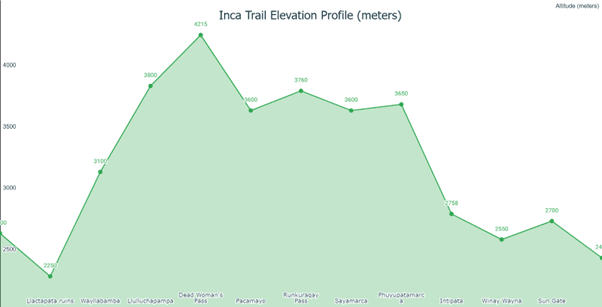
To have a better understanding of the varying levels of the Inca Trail elevation during pivotal sections of the route, see the chart below:

Inca Trail Elevation Profile
Hopefully, the chart above gives you a better idea of why it’s important for you to train as much as possible before your trek. And during the trek, it's also vital that you ascend towards Machu Picchu as slowly as possible. After all, it’s not a race and all about the incredible journey through Peru.
Dealing With Altitude Sickness On The Inca Trail
The biggest problem that comes with increasing elevations is altitude sickness.
On the highest points of the Inca Trail, some hikers experience unpleasant symptoms. Common symptoms of altitude sickness include headaches, nausea, and fatigue. At the very least, you will find it difficult to breathe as the air becomes thinner higher up.
Altitude sickness on the Inca Trail is rarely severe. Even so, you should ascend slowly and drink lots of water. Let your guide know if you are struggling and especially if your symptoms get worse. Guides are required to carry oxygen tanks in case of emergencies.
Peru’s Top 5 Highest Cities
As you can see Cusco is one of Peru's highest cites. As is Puno and Juliaca if you're planning to visit Lake Titicaca.
City Rank (By Altitude) | Height (metres) | Height (feet) |
|---|---|---|
1. La Rinconada | 5,100 | 16,732 |
2. Cerro de Pasco | 4,330 | 14,206 |
3. Puno | 3,827 | 12,555 |
4. Juliaca | 3,824 | 12,545 |
5. Huancavelica | 3,676 | 12,060 |
6. Chivay | 3,635 | 11,925 |
7. Sicuani | 3,549 | 11,643 |
8. Cusco | 3,400 | 11,152 |
9. Huancayo | 3,259 | 10,692 |
10. Huaraz and Tarma | 3,053 | 10,016 |

Thanks for the Info, very helpful!