The 4-day Inca Trail to Machu Picchu is celebrated as Peru’s most famous hike. This is one of the world’s most iconic trekking experiences and provides an awesome combination of breathtaking landscapes and ancient Incan sites.
This detailed, day-by-day guide of the 4-day Inca Trail is based on my personal experience.
In this article, I will give you insights on what to expect and how to prepare for this adventure of a lifetime.
Get an Inca trail trek quote
Start planning your Machu Picchu hiking holiday.
4-Day Inca Trail - Ultimate Guide To The Classic Trek
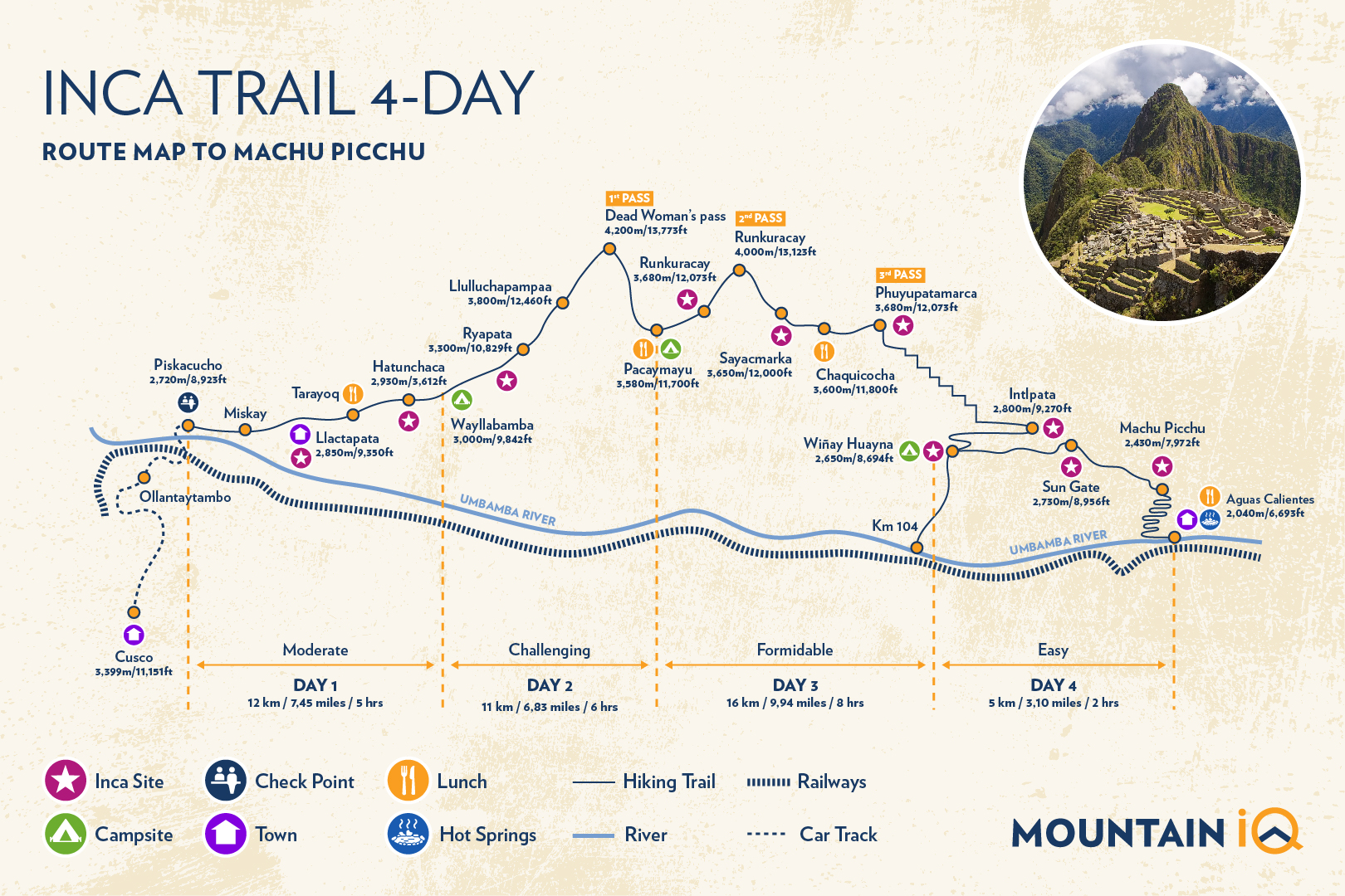
4 Day / 3 Night Classic Inca Trail Route and Distance
Our handy route map below shows the 4D/3N Classic route which typically departs from Cusco (3,399m / 11,151 ft) and ends at the iconic ruins of Machu Picchu (2,430m / 7,972 ft).
Please Note: Regarding camping sites on the route map below, the 4D Inca Trail trek itinerary can vary from tour company to tour company. See more in our article on the best Inca Trail trekking companies for epic 4-day Inca Trail tours.
The total trek distance from Cusco to Machu Picchu is roughly 45km (26 miles) and reaches a maximum altitude of 4,200m (13,775 ft). It is a moderately challenging trek that can be completed by most people, as long as they are fit and well acclimatized.
You may also like:
What You Need To Know About Booking The Classic 4-Day Inca Trail
The first thing you need to know is that permits sell out fast! The trail is world-famous, so hikers should book their tickets 6 months to a year in advance. Only 500 permits are issued per day and half of those are reserved for porters/guides.
Although the classic trek is 4D/3N, most tour companies will arrange your pre and post-trek hotels. This means most tours are in fact 7D/6N (with one acclimatization day included).
The classic 4-day Inca Trail to Machu Picchu should include your ticket to Machu Picchu. This is usually a Circuit #3 ticket. Most people consider this the best circuit as the tour goes through the citadel and to the top of the mountain. If you want to do another route, then you will need to purchase an additional ticket.
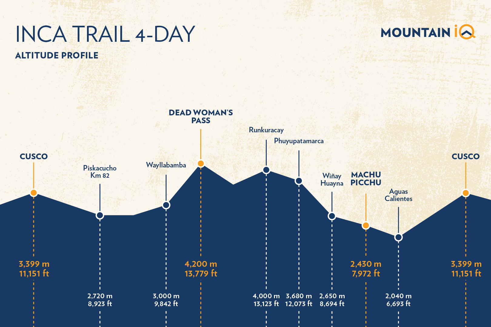
Check out our handy altitude profile for the 4-day Inca Trail below to give you a better idea of the elevation you'll experience during your trek.
You may also like:
Looking for a day tour? Here are my 5 favourite day tours around Cusco:
- Rainbow Mountain day trip (with meals)
- Moray and Salt Mines Quad Bike Tour
- Sacred Valley day tour
- Humantay Lake day tour
- Machu Picchu and Huayna Picchu entrance tickets
See more Cusco day trips.
Why Choose The 4-Day Inca Trail To Machu Picchu?
The Inca Trail is a chance to follow in the footsteps of ancient kings. For many, this is the one-and-only choice to do the original trek to Machu Picchu. Nothing beats the sense of achievement and wonder when you pass through the sun gate after 4 days of trekking.
The 4-Day Inca Trail gives you the best opportunity to see Peru’s sub-tropical Andean mountain environments. Trail habitats include cloud forests, alpine tundra and jungle landscapes. You will get to experience remote areas free from roads and human presence.
The impressive array of Inca archaeological sites is another top reason to hike the Inca Trail. Some of these ruins (Runcuracay, Phuyupatamarca, Wiñayhuayna, and Machu Picchu itself) are worthy of a visit on their own!
You may also like:

Get an Inca trail trek quote
Start planning your Machu Picchu hiking holiday.
4-Day Inca Trail To Machu Picchu - Daily Itinerary
Below is a typical itinerary for the 4D/3N classic route.
Day 1: Cusco – Ollantaytambo – KM82 – Wayllabamba
Day one consists of an early morning car or bus ride through the Sacred Valley, and a relatively easy ~12km (7.5 mi) trek.
You will be collected at your hotel early in the morning (usually between 05:00-06:00) by your tour operator and transported from Cusco into the Sacred Valley (some companies start their tour in Ollantaytambo).
The drive takes approximately 3 hours to reach the starting point, called KM82 (named as such as it is 82KM by train from Cusco).
On the drive, you will pass through the towns of Chinchero, Urabamba and Ollantaytambo. You may even stop for about an hour in either Urubamba and Ollantaytambo, where you can grab some breakfast and last minute supplies.
The trail from KM82 first crosses the Rio Vilcanota (often referred to as the Urubamba River) before climbing steeply up from the Rio Cusichaca to a small local village.
You may also like:
On the other side of the village, you will see an Inca fort called Huillca Raccay. This was built as a strategic look-out point into the Urubamba valley and was likely used to control the Cusichaca valley.
You will also be able to see below you, on the other side of the river. From here, there is another impressive Inca site called Patallaqta.
Patallaqta was discovered by Hiram Bingham in 1911, on the same expedition when he discovered Machu Picchu. It is an extensive Inca ruin that is thought to have been an agricultural settlement used to grow and supply food for the inhabitants of Machu Picchu.
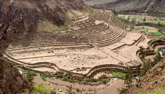
Llactapata, an impressive Inca ruin discovered by Hiram Bingham in 1911.
The route continues for another 7-8km (4-5 mi) along a series of gradual undulations to the small village of Wayllabamba (sometimes spelled Wayllapampa), which means ‘grassy plain’ in Quechua, (3,000m / 9,842 ft).
You will most likely camp here from the night. However, some trekking companies continue a little further on to Inca trail campsites near Ayapata (3,300m / 10,827 ft).
Please Note: Wayllabamba is the point at which trekkers on the Salkantay / Inca Trail Combo trek join the Inca Trail. Pack animals are allowed up to this spot on the trail before porters carry on for the rest of the way up.
Day 2: Wayllabamba – Llulluchapampa – Warmiwanusca – Pacamayo
You will be waking up early for breakfast and to prepare for the toughest trekking day. Day 2 is similar in trekking distance to Day 1 which is about 11km (6.83 mi) but involves going up and over the Warmiwanusca Pass (aka Dead Women’s Pass), a 4,200m (13,779 ft) traverse.
The beginning of the trek is straightforward. After your first hour, you will reach a bridge that crosses the Huayruro river. Here, you will find a campsite which has toilets. If you feel the call of nature in the morning, it might be best to hold it in until you reach this point.
Fast Fact: 'Huayruro' refers to a small tree that has red and black seeds. You will commonly see these colours on the ponchos of porters from Ollantaytambo. For this reason, porters from this area are often called Huayruros.
From here, the trail begins to steepen. It winds its way through cloud forest terrain and after nearly hours of hiking, eventually reaches the small village of Llulluchapampa (3,800m / 12,460 ft).
After this juncture, you will trek another 1.5-2 hours to reach the top of Warmiwanusca Pass (aka Abra de Huarmihuañusca or ‘Dead Woman’s Pass). This notorious pass is situated at 4,200m (13,779 ft).
The route up can be hot and intense if the sun is out (wear sunscreen), or cold and cloudy and foggy with icy winds. Be prepared for all conditions by wearing multi-layered clothing.
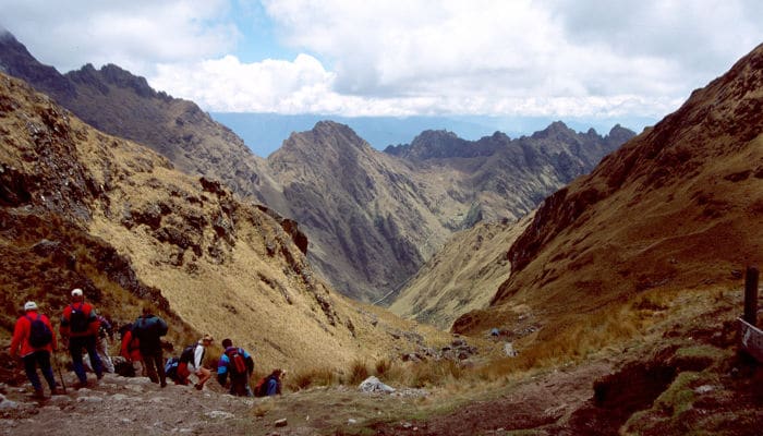
The view from Dead Woman's Pass (4,200m) on the Inca Trail.
Now, you can celebrate your successful climb to the highest point of the Classic Inca Trail. After catching your breath for a few minutes, you will descend for about 2km (1.2 mi) on a steep trail to the campsite for that night. This camp is located at Pacaymayu (3,580m / 11,700 ft). You will be glad to know that there are toilet facilities here.
Please Note: Dead Women’s Pass is named as such not because women died on the pass but rather for its shape. When viewed from the descending valley, the mountain slope resembles a supine woman.
Day 3: Pacamayu – Runkurakay – Sayacmarca – Phuyupatamarca – Winay Wayna
Day 3 is another challenging day that covers about 16km (9.94 mi) and traverses two small passes.
The day begins with an hour-long trek up to the ruins at Runkurakay (3,680m / 12,073 ft). This Inca site is believed to have been used as a watchtower over the Pacaymayu valley.
After a second hour’s trekking, you will reach the Runkurakay Pass (aka Abra de Runkuracay). This pass is the second of the Classic Inca Trails major passes. It has a maximum altitude of 4,000m / 13,123 ft. From here, you will be walking on beautifully paved pathways and stone staircases. These structures are still intact from the days of the Incas.
The first staircase down from Runkurakay Pass is relatively steep, so take care with your footing. You will reach the Sayacmarca ruins (3,650m / 12,000 ft) an hour or so after the second pass.

Get an Inca trail trek quote
Start planning your Machu Picchu hiking holiday.
The purpose of Sayacmarca is still unknown but the site’s name means ‘Inaccessible Town’. This accurately describes its well-protected position at the foot of three steep cliffs. The main feature of these ruins is the beautiful stone staircase.
From here, the trail passes through an original Inca tunnel before climbing up to Phuyupatamarca, the third and final pass at 3,680m (12,073 ft). On a clear day, you will be presented with fantastic views of Salkantay Mountain (6,217m / 20,397 ft) in the south and Mount Veronica (5,860m / 19,226 ft) to the North.
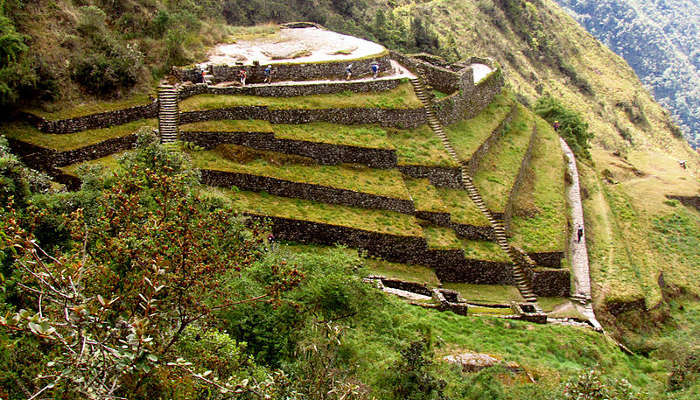
Phuyupatamarca or Puyupatamarca is also known as 'La Ciudad entre la Niebla' ('The City Above the Clouds').
Just after the pass, you will reach Phuyupatamarca, one of the most impressive Incan sites on the trail (bar Machu Picchu). Phuyupatamarca or Puyupatamarca is also known as ‘La Ciudad entre la Niebla’ (‘The City Above the Clouds’). An apt description for a place 3,680m (12,073 ft) above sea level.
The site is accessed via a steep path that passes 5 original Incan baths. These may have been used for spiritual or ritual reasons.
Leaving Phuyupatamarca, you will encounter a staircase of 1,000 steps. Prepare your knees (and your mind) for a tough descent. Go slowly and make sure of your footing.
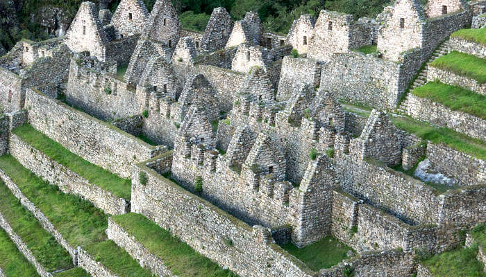
Wiñay Wayna, an Incan site near the final campsite of the same name, is located on the Inca Trail.
After 2-3 hours of trekking through the cloud forest, you will reach the campsite at Winay Huayna (which is the Quechua name for ‘Forever Young’).
Just south of the campsite are the ruins of Winay Huayna, situated at 2,650m / 8,694 ft. The area was likely used as a final resting spot before reaching Machu Picchu. The site has a number of Incan baths and were likely used in ritual cleansings in preparation for arrivals at Machu Picchu.
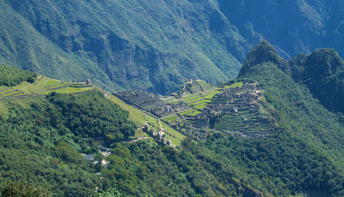
The view of Machu Picchu from Inti Punku (the Gate of the Sun).
Day 4: Winay Wayna – Inti Punku – Machu Picchu – Aguas Calientes – Ollantaytambo – Cusco
From Winay Huayna, you will awake early (around 04:30) to have breakfast and start the 1.5-hour trek to Inti Punku (the Sun Gate), situated at 2,750m / 8,956 ft.
The initial part of this trek may happen before sunrise. In this case, you might need to use a head-torch (which you can find more details about on our Inca trail packing list). Although, most operators only hit the trail around 05:30 when dawn breaks. The early departure is on account of trying to catch the sunrise over Machu Picchu. The first rays shine through between 06:30 and 07:00.
The trail from Winay Huayna runs through a cloud-forested contour path. After the forest, you will reach about 50 steep flights of stone stairs to Inti Punku.
At the top of the staircase, you will be presented with an unforgettable view as the famous Inca site of Machu Picchu is revealed through the Sun Gate.
You will get 30-40 minutes to soak in these first views of Machu Picchu from Inti Punku. Then, you will descend down a gradual path into the Citadel. From here, you will register with the authorities and put your backpack in storage.
Most tour operators include a full 2-3 hour tour of the city before giving you free time to explore the ruins. If you still have the energy and are not afraid of heights, then I highly recommend climbing Huayna Picchu (the iconic mountain behind Machu Picchu).
Please Note: When climbing Huayna Picchu, you will need to book your place prior to arriving at Machu Picchu. There are only 400 climbing permits a day with two departure times (07:00 and 10:00am). Like the Inca trail, it is important to book early. You can get tickets here.
After exploring Machu Picchu for a few hours, you will either need to catch a bus or walk down to Machu Picchu town (aka Aguas Calientes) in the valley below. The bus trip is usually included in your Inca trail tour price (see cost to hike the Inca trail and cheap Inca trail tours). The walk down takes approximately 2 hours and is worth considering as it provides fantastic views of Machu Picchu’s terraces.
Most tour operators will have booked a mid-afternoon train journey for you back to Ollantaytambo, where they will also have organized a bus or private car to transport you back to Cusco. If you depart from Aguas Calientes (2,040 m / 6,693 ft) at 15:00, you will get back to Cusco around 20:00.
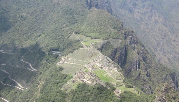
The view of Machu Picchu from Huayna Picchu (aka Wayna Picchu or Wayna Pikchu).
Extended / 5-Day Inca Trail
One can also do a 5D/4N Inca Trail itinerary. These packages include a night in a hotel in Aguas Calientes and an additional day at Machu Picchu.
This is ideal for those who would like to spend more time at Machu Picchu (perhaps climbing Machu Picchu Mountain or Putucusi). With the 5-day Inca Trail, you will also have the opportunity to visit the hot springs at Aguas Calientes.

Allison, thank you for this great break down!! We are retired military in our late 50s, but in great shape and have hiked in the Rockies and Sierras. This hike is one of our top bucket list items! We now know we want to look for a 5 day trip to enjoy the hot springs and extra day and that we have to reserve for the extra permit to do the hike up to the Mt over Machu Picchu. Now we just have to find a trip that fits our budget! Are there affordable air Bnb options for an additional night before the bike in Cuzco?
Hi Rob n Lisa, yes, there are tonnes of accommodation options in Cusco. AirBnB’s aren’t great in Cusco, you’re better offer searching for a hotel. Here are some recommendations: https://www.machupicchutrek.net/best-hotels-in-cusco-peru/. In terms of a local trek operator, I recommend checking out Skyhook: https://www.skyhookadventure.com/go/machu-picchu
Alison,
Your description of the Inca Trail is the most detailed and exciting one that I have read so far. I'm thoroughly impressed with your knowledge, training and passion for Nature Conservation. I also appreciate your maps and love your photographs.
Thank you so very much!
Nancy Levyssohn
[email protected]
Hi Nancy, thank you for those kind words, you’ve made my day! Glad that you have found this article useful.